
|
(1) View From Japanese Gardens
|
Vision PDX Project
Adopted by the City Council of Portland in 2007, VisionPDX is now an instrumental tool in Portland’s planning agenda (2). The VisionPDX project surveyed 15,000 Portland residents regarding their vision for the future of Portland (2). The project served the city planners well to identify shared goals among residents for their visions of a long term Portland. The three main shared goals from the surveys consist of: community connectedness, equity & accessibility, and sustainability (2).
For community connectedness, Portlanders stressed the need for big city amenities with a small town feel.
Portland residents addressed equity and accessibility by emphasizing innovative approaches to meeting more than just basic needs.
For sustainability, the survey showed that residents were concerned with “meeting the environmental, social, cultural and economic needs of the present while ensuring the similar needs of future generations.” (2)
Vision PDX proves that urban design relates to more than just the built environment.
Historical & Contemporary Case Studies
(1) Grid Comparisons
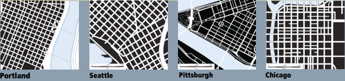
The Planning and Sustainability department of the city of Portland has explored and sought relevancies from other great American metropolises. The Planning and Sustainability department critically analyzes portions from certain cities and successful aspects are related to Portland’s urban areas. Portland looked at seven historical case studies to find inspiration from how other cities over time have creatively addressed urban design problems that may be pertinent to Portland. The historic cities included Barcelona, Edinburgh, Glasgow, Philadelphia, Savannah and the historic Kyoto district (1). The categories examined included the case study cities relationship with the grid, topography and character and identity (1). The nine contemporary case study cities were selected for either or all of four main reasons including: a recent plan update by the case study city, comparable population or geographic sizes of their downtown, a relationship or proximity with water, or certain noteworthy aspects of the city’s plan (1). The cities considered with relevancies to Portland included: San Diego, Seattle, Atlanta, Milwaukie, Minneapolis, Charlotte, Chicago, Pittsburgh and a renewed study of Portland (1). The analysis returned six key recommendations for Portland to focus on. Most notably, the recommendations stress the role that urban design plays in Portland’s identity with architecture and innovative sustainable design.
Skyline & Visual Identity
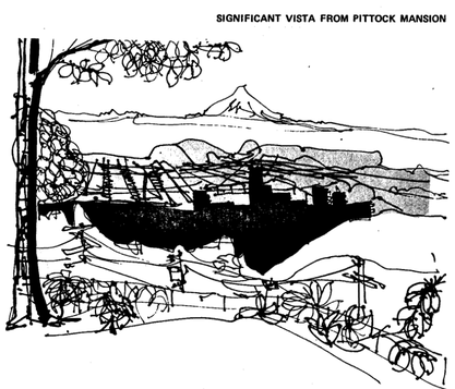
(4) Sketch from Pittock Mansion
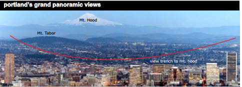
Portland employs a step-down development model as it pertains to the Willamette River from the western edges to riverbank. The idea is too ensure new office development while preserving views of Mt. Hood and the Willamette River (3). The Planning Bureau considers the preservation of these views enhances the marketability of Downtown Portland (3). Policy 12, Urban Design, of the 1988 Central City visits the importance of identifying and protecting significant public views (3). The most meaningful views that residents consider significant are those of Mt. Hood, Mt. St. Helens and the Willamette River, and those views are the most protected by building height restrictions. The built skyline plays an important role in framing the important views in the area, but buildings may also adversely affect the quality of the views. Both the 1972 and 1988 plans address the impact of building height and restrict the height of new development. The 1972 Downtown Plan identified vista corridors, views of downtown from the West Hills, and gateways into the city as important considerations for all future development in the central city (4). The most evoked image of Portland on a large scale is that of Mt. Hood overlooking the downtown, from the Japanese Gardens on the slopes of the West Hills (photo at the top of this page). Currently the city wishes to keep the open trench view of Mt. Hood anchored by the two large buildings on each side of downtown by restricting the height of development between the two towers. Portland has allowed tall construction in both the Pearl District and the South Waterfront districts without view restrictions as they sit outside the open view trench created by the U.S. Bancorp Building (Big Pink to locals) and Wells Fargo towers (1).
1. Portland Bureau of Planning. "Urban Design Assessment: Central Portland Plan." Portland.gov. www.portlandoregon.gov/bps/article/218810 (accessed February 6, 2013).
2. Portland Bureau of Planning. "Portland Plan: Conditions, Trends & Issues." Portland.gov. www.portlandoregon.gov/bps/article/181536 (accessed February 26, 2013).
3. Portland Bureau of Planning.Central city plan: adopted by the Portland City Council March 24, 1988. Portland: The Bureau, 1988.
4. Portland Bureau of Planning.Downtown plan: planning guidelines/Portland downtown plan, as adopted by City Council, December 1972.. Portland: The Committee, 1972.
Anthony Monaco
