
|
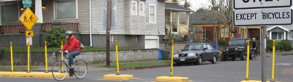
Cyclist using the Greenway (2)
|
Portland has had significant success in creating an American city with popular mass transit and safe, convenient bike pathways: learn more. In 1968 Governor Tom McCall started an investigation of converting Harbor Drive into open park space (1). The Waterfront park was successfully built in 1978, allowing the residents to bike or walk alongside the Willamette river (1). For the first time in the US a highway was removed and not replaced (1). Another space that was repurposed for transit and pedestrians was Pioneer Square (1). The proposal of a new parking structure was turned down in 1960’s and in 1972 the Downtown plan converted the space into a central square. By 1984, with the support of TriMet the space was opened as main station for buses and light rail as well as gathering place for the community with frequent events and vendors (1).
Currently underway are the city’s Neighborhood Greenways, converting a network of streets throughout the city that are designed to have low auto traffic and facilitate cycling (2). Started in 2009, these streets have specific goals as well as elements to ensure the cyclists feel comfortable:
Also with the restructuring of these street to more pedestrian friendly there has been addition of “green streets”(2). These features are landscaping elements extending the curb and naturally managing the storm water with plants instead of entering into the sewage(2). The green streets extend the calming effect of the city’s parks as well. The landscape is also designed to be low to preserve visibility from the street(2). Here is a map below of the current projects completed and underway:
Currently underway are the city’s Neighborhood Greenways, converting a network of streets throughout the city that are designed to have low auto traffic and facilitate cycling (2). Started in 2009, these streets have specific goals as well as elements to ensure the cyclists feel comfortable:
- Speed bumps and traffic diverters to reduce vehicles from using the streets to cut through.
- Sharrows are pavement signage to warn drivers of cyclists as well as improved crossings and curb ramps for pedestrians. They consist of two arrows and a bike.
- Reduce speed limits
- Directions on the pavement and signage on the destination of the Greenway as well as close by landmarks, districts and parks.
- Changing directions of stop signs to create through routes for biking.
Also with the restructuring of these street to more pedestrian friendly there has been addition of “green streets”(2). These features are landscaping elements extending the curb and naturally managing the storm water with plants instead of entering into the sewage(2). The green streets extend the calming effect of the city’s parks as well. The landscape is also designed to be low to preserve visibility from the street(2). Here is a map below of the current projects completed and underway:
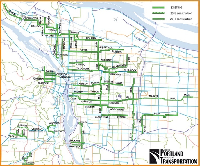
Map of Current Greenways (2)
1. Johnson, Steven. "Origins and Development of Environmental and Sustainability Movement in Portland, Oregon." Steven Reed Johnson Portland Oregon, USA. stevenreedjohnson.com/stevenreedjohnson/civicpdxEnriro_files/Environment.pdf (accessed February 16, 2013).
2. "Neighborhood Greenways + Bicycle Boulevards | The City of Portland, Oregon." City of Portland, Oregon. http://www.portlandoregon.gov/transportation/50518 (accessed February 28, 2013).
2. "Neighborhood Greenways + Bicycle Boulevards | The City of Portland, Oregon." City of Portland, Oregon. http://www.portlandoregon.gov/transportation/50518 (accessed February 28, 2013).
Lara Jansen
