
|

Pedestrian Paths (1)
|
During the end of the 1960's, Portland made a few pivotal decisions that changed the course or transportation planning in the city. The decisions deliberately set out to lessen Portland's dependence on automobile travel.
Waterfront Park
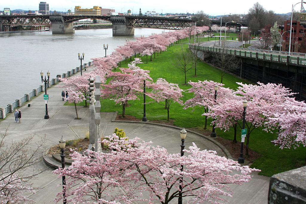
Waterfront Park (2)
The project that best represents the dramatic change in planning is Waterfront Park along the Willamette. In connection with the city beautiful from previous years, the project set out to remove Harbor Drive and buildings along the riverfront and replace the region with a new park.(3) The 37-acre park was completed in 1978 and in 1999 an extension went even further by doubling the amount of open space. (3) The project is considered the key project that sparked further open-space and pedestrian friendly projects in the city.
TriMet
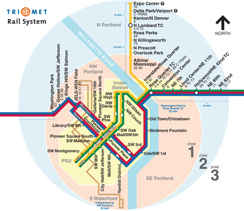
TriMet Rail System (4)
Prior to 1969, transit use in the Portland area had been steadily falling as automobile use increased. The bankruptcy of Portland’s last transit company, the Rose City Transit Company, prompted councilmen to address the future of Portland transit. On January 14, 1969 the city council created the Tri-County Metropolitan Transportation District of Oregon; TriMet. By the end of the year, the Rose City Transit Company agreed to transfer operation of the transit system to the city. (5) Operation by TriMet began December 1, 1969. TriMet immediately set out to increase Portland transit use by joining all local bus services, building Park & Ride lots, and increasing the number of buses. (5) To further increase the number of transit riders, TriMet made the decision to offer free transit along a central Portland transit loop in 1975. The route, known as Fareless Square, not only dramatically increased ridership, but nearly eliminated the need to use cars for short trips near downtown. This aided in the relief of traffic congestion downtown.
Portland's Master Bike Plan
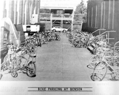
Bicycle Parking 1974 (6)
In addition to public transit options, cycling is the main mode of transportation for thousands of Portlanders. (7) In 1973, after a resident effort to improve bicycle transportation, Portland’s first bicycle plan was completed. The plan followed many of the same guidelines set forth by the 1996 Bicycle Master Plan. The plan sets forth five key elements needed to encourage people to use bicycles as their main mode of transportation. (7)
Five Key Elements
The transportation section of the Comprehensive Plan states that its goal is to:
Make the bicycle an integral part of daily life in Portland, particularly for trips of less than five miles, by implementing a bikeway network, providing end-of-trip facilities, improving bicycle/transit integration, encouraging bicycle use, and making bicycling safer. (7)
Five Key Elements
- Suggesting policies and objectives to be part of the transportation section of the Comprehensive Plan
- Recommending a viable bicycle network
- Providing end-of-trip facilities for cyclists
- Creating a link between bicycle and transit (such as bike racks on trolleys)
- Educating the public on bicycling and encouraging them to ride.
The transportation section of the Comprehensive Plan states that its goal is to:
Make the bicycle an integral part of daily life in Portland, particularly for trips of less than five miles, by implementing a bikeway network, providing end-of-trip facilities, improving bicycle/transit integration, encouraging bicycle use, and making bicycling safer. (7)
Downtown Transit Mall
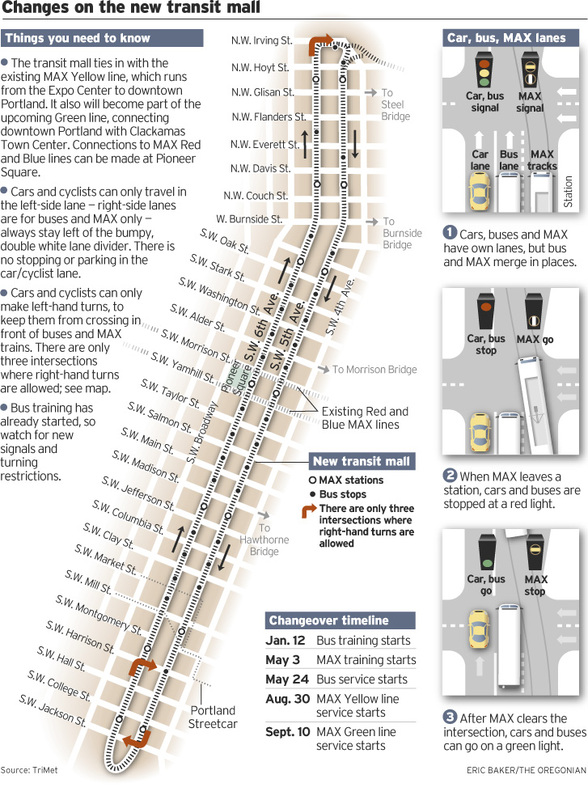
Portland's Transit Mall (8)
In 1978, Tri-Met continued its efforts to expand ridership in Portland by completing the Downtown Transit Mall. One of the first developments of its time in the United States, the mall covered twenty two blocks and traveled through the dense core of downtown Portland. (9) The success of the mall confirmed the project as a model prototype for redevelopment. Further, it showed haw transportation can catalyze such redevelopment. (9)
Shortly following the Transit Mall opening, voters approved the creation of a Metro in 1978. The completed MAX line was one of the first modern light rail systems in the country. (5) Over the next 20 years, Portland Metro lines expanded to cover central Portland and the surrounding communities.
Portland Streetcar and Airport MAX
In 2001, TriMet completed the Airport MAX Red Line connecting downtown Portland to Portland International Airport. The project was the first train-to-plane transit service on the West Coast. (5) The same year, the Portland Streetcar system brought streetcars back to Portland. This was the first new street car system in the United States since WWII. (5) The system serves downtown Portland; offering shorter distance transit within central Portland.
Over the last twelve years, transportation planning in Portland has continued to be an integral part of Portland’s success. The MAX lines have continued to expand offering Portlanders of all backgrounds accessibility to all Portland has to offer.
Looking toward the future, the bicycle plan for 2030 hopes to further decrease Portland’s dependence on the automobile.
Looking toward the future, the bicycle plan for 2030 hopes to further decrease Portland’s dependence on the automobile.
Bicycle Plan For 2030
The Bicycle Plan for 2030 looks to reexamine Portland's bicycling needs and suggest new approaches to encouraging cycling as a daily mode of transportation. The plan recommends expanding the network bike routes from 630 to 962 miles. (10) In order to due this the plan suggests three key strategies. (10)
- Create safe attractive bike routes to carry more cyclists and serve all types and all ages of riders
- Make the bicycle network dense enough that anyone can find a route
- Create a network that gets riders where they want to be easily
1. (Image) http://emilyingebricson.com/wp-content/uploads/2011/04/922278_10089314.jpg
2. (Image) http://upload.wikimedia.org/wikipedia/commons/8/86/Waterfront_Park,_Portland.jpg
3. "Portland's Harbor Drive | Congress for the New Urbanism." Congress for the New Urbanism. http://www.cnu.org/highways/portland (accessed March 6, 2013).
4. (Image) http://www.thealbert.com/images/photos/transit/trimet-map.jpg
5. "TriMet: History - The TriMet Story." TriMet: Public Transit in the Portland Area. http://trimet.org/about/history/trimet_story.htm (accessed February 26, 2013).
6. (Image) http://www.portlandoregon.gov/shared/cfm/image.cfm?id=336936
7. "Bicycle Master Plan." City of Portland Office of Transportation 1 (1996): 1-76.
8. (Image) http://blog.oregonlive.com/news_impact/2009/01/GS.61MALL123.jpg
9. "TriMet: The Portland Transit Mall." TriMet: Public Transit in the Portland Area. http://trimet.org/portlandmall/index.htm (accessed February 26, 2013).
10. "Portland Bicycle Plan for 2030." City of Portland Bureau of Transportation 1 (2010): V-VII.
Jillian Emery
