
|
(1) Central City Plan
|
Olmstead Plan 1903: City Beautiful Influence
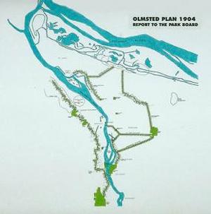
(3) 40 Mile Loop 1904
Frederick Law Olmsted, the creator of New York City’s Central Park, was summoned to the city of Portland after the success of the Chicago Worlds Fair (2). Portland was in the midst of preparing for the Lewis and Clark Centennial Exposition set for 1905. The City Beautiful Movement had also inspired the city of Portland and the Olmsted brothers were obliged to design an open space system that would accommodate prevailing and future open space needs (1). The brothers compiled the 1903 Portland Parks Report with 18 guidelines or suggested systems (2). Guidelines would range from “#1 The Importance Of Municipal Parks” to, “#16 Park Systems Should Be Governed By Qualified Individuals” and “#18 Parks Should Be Managed Independently Of City Governments”(2). The second part of the Olmsted report also included proposals regarding multiple city squares, playgrounds, boulevards, and shorelines in addition to 18 pre existing and proposed parks throughout the city (2). This highly acclaimed, 123-page report compiled for the city of Portland is archived in the Library of Congress (2).
Bennett Plan 1912: Portland, A Living Organism
Following the 1905 Lewis and Clark Expedition, Portland was anticipating a population of 2 million residents. The Portland Improvement League would look to a protégé of Daniel Burnham to continue the City Beautiful Movement development proposals (1). Edward H. Bennett would envision the city as a living organism with the business center to be seen as the heart, the street circulation as the arteries, and the parks considered the lungs (1). The plan had proposed parks and boulevards to increase viewpoints and street vistas to create a formal sense of civic identity (1). Portland continues to abide by these ideals with height restrictions that preserve vistas from the west hills. Bennett’s plans would also widen thoroughfares to accommodate the park blocks that Portland residents treasure to this day.
Cheney Plan 1921: Birth of Bridgetown
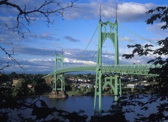
(4) St. Johns Bridge
In 1921, the Portland Planning Commission was looking to build upon the more difficult to implement ideas of the 1912 Bennett Plan. This is also the first plan that moves away from the City Beautiful Movement ideas of urban design with emphasis on regional views of planning and incorporating major streets and boulevards that link Portland to the surrounding area. The Cheney Plan also emphasized safer riverfront access by protection for greater public access in industrial areas (1). Three particular elements that persist from the Cheney Plan are three notable bridges: Burnside, Sellwood and St. Johns (1).
Bartholomew Report 1932: The Great Depression
In 1932, the city of Portland was yearning to escape the grips of the Great Depression and headed toward an inward focused strategy. The Bartholomew Report was the first plan to clearly articulate ideas for Portland’s Central City (1). The plan called for improvement, or widening of 5 of the 9 bridges over the Willamette River that linked downtown to the east side of the river to accommodate for the influx of automobile traffic. Also planned for the river was the addition of the west side riverfront park stretching from the southern edge of downtown Portland past the Burnside Bridge on the northern edge of downtown (1).
Moses Report 1943
Portland was one of the few metropolitan areas to see population increases through the Great Depression. This trend turned boom after World War II. Robert Moses and a team of engineers with highway, bridge and transportation experience were summoned to Portland (5). Moses was only in Portland for a week, but his planning agenda in Portland echoed from 1945 to 1973 (5). His report proposed a $60 million dollar construction program with $20 million to construct a downtown freeway loop, (I-405 and I-5 loop). His plan also consisted of a river level freeway along the Columbia River up to the Cascade Locks from downtown Portland, now known as Interstate 84 along with the Sunset Highway and Vista Ridge Tunnel that connect the western suburbs to the city center (5). The Moses Report was sponsored and supported by the City of Portland, the County of Multnomah, the Port of Portland and many other local organizations (1). The largest, or loftiest plan for Portland to date in its time had met much resistance and is still criticized to this day, but the freeway loop that bares the brunt of the criticism is at least an object of containment to keep the city center contained (5). The impact on shaping the agreed upon boundary of the downtown area would last until 1988 when planners would include neighborhoods on the east side of the Willamette River into what is now considered Downtown Portland.
More on Transportation
More on Transportation
Comprehensive Development Plan 1966
To accommodate the Federal Housing Act, the City Planning Commission developed the 1966 Comprehensive Development Plan of Portland (1). The plan was designed to address and Federal Housing Act mandates, which included urban renewal objectives. The plan did propose increasing the amount of freeways in the city to ease congestion in neighborhoods, however, these proposals were not implemented. The proposals to increase freeways were attached to the idea of neighborhoods as independent cells, and each cell was to be afforded its own park, school and retail sector (1). Neighborhoods in Portland became distinguishable and identifiable and the 1966 plan spawned the neighborhood revolution of the 1970’s.
1972 Downtown Plan
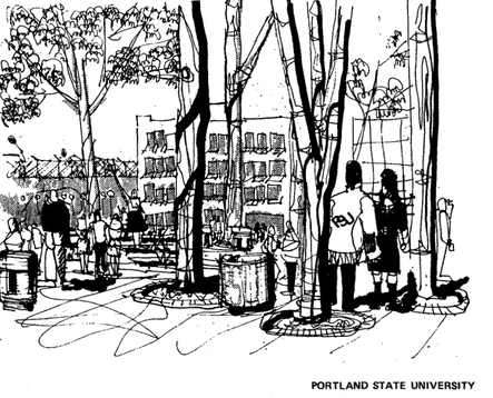
(7) Planning for PSU
The 1972 Downtown Plan of Portland saw a shift in the thinking of Downtown Portland. There was wide concern that Portland was losing commercial and residential markets to the fast expanding suburbs (6). Inspired by the writings of Jane Jacobs, Portland began to focus its attention on public spaces and the downtown central business district. The first goals to be outlined in the 1972 Downtown Plan were to give priority to the increasing number of residential areas near the central city for diverse age and income groups (7). The general goal was to provide a quality environment in which people can live with respect to the fact that downtown neighborhood residents reside adjacent to an area vital to growth for the whole of Portland (7). A notable specific goal was to establish a way to ensure that downtown residents had a voice in decisions affecting the downtown areas vitality. The plan also divided the downtown area into special districts to address accessibility on a district-by-district basis. Also given special attention near the top of the plans list of goals was the idea that Portland State University is to be treated as an “urban university” and as such and should be given the same accessibility and attention as the rest of the city center (7). For instance, zoning around PSU and the park blocks should be given special considerations, look to expand low-income options for students, minimize congestion and encourage interaction between the city center and PSU (7). The plan was especially notable for assigning planning element guidelines to the following 17 categories:
Land Use: Office, Housing, Retail, Industry, Entertainment, and Community Facilities.
Environment: Open Space, Traffic Free Areas, Air Quality, and Visual Image.
Circulation: Pedestrian, Vehicle, Mass Transit, Parking, Service & Loading, and Intercity Bus Terminal.
Building Density: Density. (7)
The 1972 Downtown Plan took a particular interest in housing in the central city since the number of residences plummeted 60% from 1950 to 1970 (12). The 1972 Downtown Plan was the most comprehensive planning document to date for the downtown and the plan was adopted into the 1988 Central City Plan. It has remained a significant influence on the planning of the Portland Central City (1).
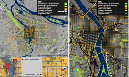
1988 Central City Plan
(1) Diagram of Connectivity for both Sides of the Willamette
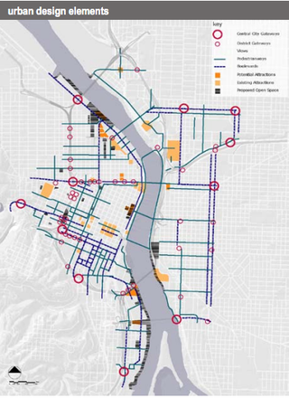
Much different from the 17 first phase action items from the 1972 plan, the 1988 Central City Plan had over 400. Only 12% of the 464 action items from the 1988 Central City Plan have been fully completed, however, the remaining 88% of the recommended action items are in either in progress, under construction or still on the planning agenda (8). Through this plan, Portland was attempting to create enjoyable atmospheres for pedestrians through urban design principles. The focus on urban design successfully combined elements of land use, transportation, and parks and open space, with urban design considerations, such as gateways, attractions, and relationships to the river (1). The adjacent photograph is a depiction of these elements in a map of the downtown area to illustrate the relationship of the urban design elements.
The plan also included the east side districts of the Willamette River as a priority to maintain the vitality of the downtown on the west side and organize the city to embrace the river (1). Portland was now embracing the Lloyd Center shopping plaza on the east side of the Rose Quarter as an extremity of the central city. The city was now encompassing a total of three new neighborhoods on the east side of the river into the downtown area as well as the North Macadam section just south of the old boundary. The neighborhoods on the east side are the Central Eastside, Lower Albina and the Lloyd Center areas.
The plan also included the east side districts of the Willamette River as a priority to maintain the vitality of the downtown on the west side and organize the city to embrace the river (1). Portland was now embracing the Lloyd Center shopping plaza on the east side of the Rose Quarter as an extremity of the central city. The city was now encompassing a total of three new neighborhoods on the east side of the river into the downtown area as well as the North Macadam section just south of the old boundary. The neighborhoods on the east side are the Central Eastside, Lower Albina and the Lloyd Center areas.
1. Portland Bureau of Planning. "Urban Design Assessment: Central Portland Plan." Portland.gov. www.portlandoregon.gov/bps/article/218810 (accessed February 6, 2013).
2. Hockaday, Joan. Greenscapes: Olmsted's Pacific Northwest. Pullman, Wash.: Washington State University Press, 2009.
3. (Image) hollistic, the Olmsted Brothers Firm. The document clearly lays out that the park system of a city should be designed as well as acquired in a, and comprehensive manner stating: . "The Olmsteds and conceptual origins | Museum of the City." Home | Museum of the City. http://www.museumofthecity.org/exhibit/olmsteads-and-40-mile-loop (accessed February 27, 2013).
4. (Image) "Portland homes for sale - Portland Real Estate Search- Portland Relocation guide." Portland homes for sale - Portland Real Estate Search- Portland Relocation guide. http://relocationtoportland.com/ (accessed February 27, 2013).
5. Abbott, Carl. "Robert Moses In Portland." The Urban West . http://theurbanwest.com (accessed February 17, 2013).
6. Peirce, Neal R., and Robert Guskind. Breakthroughs: re-creating the American city. New Brunswick, N.J.: Center for Urban Policy Research, Rutgers, the State University of New Jersey, 1993.
7. Portland Bureau of Planning. "Portland Plan: Conditions, Trends & Issues." Portland.gov. www.portlandoregon.gov/bps/article/181536 (accessed February 26, 2013).
8. Portland Bureau of Planning.Central city plan: adopted by the Portland City Council March 24, 1988. Portland: The Bureau, 1988.
Anthony Monaco
